File:پایداری زمین.jpg
No higher resolution available.
پایداری_زمین.jpg (499 × 287 pixels, file size: 38 KB, MIME type: image/jpeg)
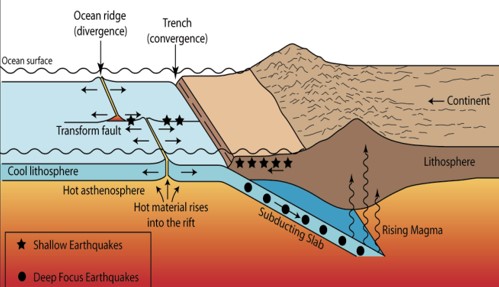
شکل4: مرز همگرا بین دو صفحه اقیانوسی و قاره ای گرفتن از پشتههای میان اقیانوسی موسوم به منطقه فرورانش Subduction Zone)
File history
Click on a date/time to view the file as it appeared at that time.
| Date/Time | Thumbnail | Dimensions | User | Comment | |
|---|---|---|---|---|---|
| current | 13:59, 10 February 2020 | | 499 × 287 (38 KB) | Hosna (talk | contribs) |
You cannot overwrite this file.
File usage
The following page uses this file: